Peak District Breaks
action packed or relaxed
you decide!

Black Rocks Country Park, Cromford. An outcrop of gritstone sculpted by the wind and rain, Black Rocks hang high above the village of Cromford with Cromford Moor behind and the High Peak Trail (the former Cromford and High Peak Railway) passing just below. It's a spectacular situation which affords a splendid view of the Derwent valley around Matlock and because of its popularity the area has been designated a country park.

Dovedale is the name given to the section of the Dove valley between Milldale and Thorpe Cloud, which contains some of the most spectacular limestone gorge scenery available in this country. Everywhere the river is flanked by steep cliffs, with numerous caves and rock pillars, of which Ilam Rock is only the most spectacular. Below Ilam Rock the valley narrows, and the path even has a short stretch where duck-boards have been erected to save walkers from having to wade the river. Then it opens out again and high on the left lies Reynard's Cave, a large cave with a natural arch in front. From the cave you have a fine view of the Dale.

Eldon Hole is one of the seven wonders of the Peak. It is the deepest local pothole; an alarming, evil-looking chasm in the side of Eldon Hill to the north of the village of Peak Forest. The hole is approximately 60 metres deep, but was once much deeper, having been part-filled by stones and rubble over the years.

HarboroRocks, Brassington.
Sculpted out of an outcrop of Dolomitic Limestone (most of the Peak is Carboniferous) on the high ridge above Brassington, Harboro Rocks are notable for their spiky outline, which can make them look really eery in misty conditions. They offer good quality, if short, rock climbs. The rocks are just off the High Peak Trail and there are no access problems.Daniel Defoe came here on his 'Tour through Great Britain' in the early 18th century and described a family living in Harboro Cave - a natural cavern in the edge which has been excavated by archaeologists who have found evidence of occupation from the Ice Age onwards.

High Tor, Matlock. is a lofty limestone crag which towers over Matlock Bath. The view from the summit area of the tor is very impressive, all the more so because the cliff edge is totally unfenced and even those with a head for heights are likely to find the drop unnerving. There is an excellent view of Matlock Bath and the Heights of Abraham on the opposite hill. For those with strong nerves a narrow walkway called 'Giddy Ledge' winds around a section of the cliff and even though this is not the highest buttress of the tor, the situation is impressive. Behind the tor summit are Fern and Roman caves, deep clefts in the rock which are not natural caves but lead veins which have been worked to a depth of up to 10 metres and a width of between one and two metres. These workings are undateable but are probably among the oldest in the area and may even be Roman in origin.

Stanage Edge, Hathersage is the largest and most impressive of the gritstone edges. Situated on the moors north of Hathersage, and visible from miles away down in the Hope Valley, it stretches for a length of approximately six kilometres (3.5 miles) from its northern tip at Stanage End to the southern point near the Cowper Stone. At about is mid-point the edge is crossed by Long Causeway, the old Roman road from Navio (Brough) to Doncaster. It is a famous location fro rock-climbing and a popular spot for walkers.
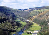
Monsal Head is a famous beauty spot with a magnificent view down Monsal Dale and up the Wye valley. The position is at a spot where the Wye, on its passage eastwards to meet the Derwent, encounters a band of harder rock and is forced to make a sharp turn southwards and carve its way through a high ridge of limestone. The view is spectacular, with the river far below, winding through a steep-sided and often rocky valley.The route of the former Midland Railway makes its way along Monsal Dale and was carried by a viaduct over the river and into a tunnel which goes right beneath Monsal Head. This is now part of the Monsal Trail, a popular route with walkers at weekends.

Winnats Pass, Castleton, is a long collapsed limestone cave system. The name Winnats is short for 'Windygates' and on a windy day you will see why it came by that name, for the wind seems to swirl around everywhere.The 'pass' part of the name is something of a misnomer - Winnats is a steep-sided limestone valley with cliffs on all sides, which climbs out of the Hope Valley onto the limestone plateau area above. The valley was created by the action of water eating away at the limestone rock - water gradually dissolves the limestone and the streams tend to find their way underground by gradually enlarging the natural cracks and fissures in the rock.