Peak District Breaks
action packed or relaxed
you decide!

Mam Tor Height: 517m (1,696 feet) Location: Castleton. Mam Tor is a hill near Castleton in the High Peak. It is also known as the Shivering Mountain on account of the instability of its lower shale layers. Indeed, in 1979 the continual battle to maintain the A625 road on the crumbling southern side of the hill was lost when the road officially closed as a through-route. Nearby are four show caves: Blue John Cavern, Speedwell Cavern, Peak Cavern and Treak Cliff Cavern.

Axe Edge Moor Height: 551m (1,808 feet) Location: Buxton. Edge Moor is the major moorland, west of Buxton in the Peak District. It is mainly gritstone. The moor is the source of the River Dove, River Manifold, River Dane, River Wye and River Goyt. It boasts England's second highest public house (the Cat and Fiddle Inn). The moor is shared between the counties of Derbyshire, Staffordshire and Cheshire, which meet on its south-western flank at the Three Shire's Head on the Dane.

Back Tor (Derwent Edge) Height: 538m (1,765 feet) Location: Derwent Moors. Derwent Edge is a Millstone Grit escarpment that lies above the Upper Derwent Valley in Derbyshire. The Millstone Grit forms the edge of the high peat moorland plateau on the eastern side of the valley above Ladybower Reservoir. An OS Trig Point marks the highest point of the Edge at Back Tor. North of Back Tor the edge extends into Howden Edge and enters the county of South Yorkshire.

Lord's Seat Height: 546m (1,791 feet)Location: West of Castleton. Lord's Seat is the highest point on Rushup Edge, a ridge in the Derbyshire Peak District of England that forms the natural barrier between the Hope and Edale valleys. The ridge forms the western end of the longer ridge to Mam Tor and Lose Hill. Its highest point, Lord's Seat at 546 m (1,791 ft), while Mam Tor lies at its eastern end, beyond which the Great Ridge runs.

Longstone Edge Height: 390m (1,300 feet) Location: North of Bakewell Longstone Edge is situated to immediately to the north of the village of Great Longstone near Bakewell. It is about 1km wide. It has been, and is, intensively quarried for galena, fluorspar and barytes, and controversially for limestone. Since Longstone Edge is a noted beauty spot and is located within the Peak District National Park there is strong local pressure for the quarrying to stop altogether.

Win Hill Height: 462m (1,516 feet) Location: Ladybower. Win Hill lies north west of Bamford. It is almost surrounded by the River Derwent to the east, River Noe to the south west and Ladybower Reservoir to the north, but a ridge running north west links it to Kinder Scout. The Roman road from Glossop over Snake Pass and descends to Hope and the old Roman base of Brough in the Hope Valley, with Hope Cross, a marker post dating from 1737, at the highest point of the road.
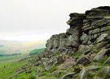
Stanage Edge Height: 458m (1,503 feet) Location: Hathersage. Stanage Edge is a gritstone escarpment famous as a location for climbing. The northern part of the edge forms the border between the High Peak of Derbyshire and Sheffield in South Yorkshire. Its highest point is High Neb. Areas of Stanage were quarried in the past to produce grindstones, and some can still be seen on the hillside-carved, but never removed. Stanage is a magnet for climbers and ramblers
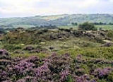
Stanton Moor Height: 323m (1,053 feet) Location: North of Matlock. Stanton Moor lies between Matlock and Bakewell. It has four Bronze Age stone circles, of which the best known is Nine Ladies. To its north lies "Stanton Moor I" (the "North Circle"), and to its south are "Stanton Moor III" (the "Central Circle") and "Stanton Moor IV" (the "South Circle"). These other circles are largely overgrown and have few remaining stones. A further circle, Doll Tor, lies a short distance west of the moor.