Peak District Breaks
action packed or relaxed
you decide!

Baslow Edge
Baslow Edge: - a short stroll of just over 3 miles that should take less than 2 hours to complete. The walk starts with a stiff pull up to Wellington's monument (rewarded with beautiful views), followed by an easy amble across the moors before reaching a breathtaking vista at Baslow Edge.
Start off by parking in the public car park in Baslow near Bakewell. This part of Baslow is known as Nether End and is just off the main A619. There are public toilets next to the car park, in addition to a tea shop and a number of pubs in the vicinity.Walk details:Cross the busy A619 with care at the pedestrian lights and walk up Eaton Hill next to the Italian restaurant 'Il Lupo'.Continue until you reach Bar Road at which you turn right. Walk on up this road, which is a 'dead end' for traffic. You arrive shortly at a track onto which you should proceed.This track ascends for a good distance to reach the open moors when Wellington's monument comes into view. About one hundred yards before the monument, just after a seat (a good vantage point), veer left onto a wide and clearly visible track.A huge boulder is just along this track. Pass by the massive rock and continue across the moors for several hundred yards until a minor road becomes evident. Before you reach the stile near this road take a left turn on a well defined path to a semi circle of stone and a Peak District Authority information site giving details of the magnificent views all around you.Retrace your steps and climb the left hand stile in the gate. Take an immediate left and follow the slim path at the side of the road. Shortly afterwards you will come to a large stile in the wall to your left just before a large tree. A National Trust sign boasts that you are entering 'Curbar Gap'.Descend this obvious path through a couple of stiles until a track veers off to the left. Follow this track through another stile that announces the start of 'East Moors Estate'. This section can be boggy in parts. Continue, rising slightly upwards to the left before reaching a bit of a 'fork' in the path. Take the right hand path that starts to descend slightly.Continue to a stile in the wall as you depart 'East Moors' onto a grassy field. Follow the wall to your right until you reach a track which you should join until another stile becomes visible just ahead and to the left of the track. Over the stile follow the faint path until it broadens as you round a bend with Chatswoth House now clearly in view straight ahead.Baslow village proper is seen down to your right. Climb a couple more stiles and you rejoin the same track you ascended an hour or so ago. Turn right and retrace your steps back to Eaton Hill and down into the car park.

Castleton Village
Castleton: - a short stroll of just over 4 miles that should take less than 2-3 hours to complete. The walk starts of in the beautiful village of Castleton, taking you passed Peveril Castle which was built around 1175, through the steep-sided confines of Cave Dale, thought to have been carved out by the rushing meltwaters from an Ice Age glacier resulting in a spectacular craggy, dry-bottomed limestone canyon, then onto Windy Knoll Cave - one of the classic sites in Peak District geology and prehistory - an impressive low cave that was the Ice Age den of brown bear, wolf and hyaena, which preyed on the mammoth, woolly rhinoceros, before going on to one of the most spectacular places in the Peak, Winnats Pass - a craggy canyon, formed 350 million years ago as an undersea channel through the coral reefs of the Carboniferous period, and finally taking you passed the famous caves and back into the village.
From the large village square, walk up Bargate and take the concealed entrance to Cave Dale (signposted Limestone Way) and pass through a stile into the dale. As the dale path steepens, with ever-expanding views beack to Peveril Castle and the cone of Win Hill in the background, it narrows again through gates and stiles to a short gated road at the junction with the Dirtlow Rake bridleway. Turn right here over a stile and then a second one (right) which leads onto Rowter Lane. Rowter Lane is followed for about a mile, passing the farm of the same name over to the right, with the great bulk of Mam Tor filling the skyline ahead. Note in the meadows over to the left, the distinctive bumps and hollows left by old lead mine workings. Several abandoned mine shafts are found here, and on the grassed-over waste hillocks, the beautiful, lead-tolerant purple and yellow flowers of the mountain pansy can be seen in summer. Reaching the B6061, go straight ahead over a stile on a grassy track to reach the abandoned quarry and gaping, low cave entrance of Windy Knoll (National Trust). Go down to the road and turn right and right again at the junction beneath the crumbling face of Mam Tor, with fine views down the Hope Valley ahead. A stile leads left across the fields around the back of Winnats Head Farm, which stands at the head of the impressive canyon of the Winnats Pass (National Trust). Walking down the Winnats is by far the best way to appreciate the soaring rock architecture of this superb little canyon which cuts through the reef limestones of Treak Cliff, which extends away to the left. A gate leads off to the right just past the Speedwell Cavern and this path leads across the face of Long Cliff below Cow Low to enter Castleton again at Goosehill Bridge. It is a short step from here to visit Peak Cavern, following the footpath alongside Peakshole Water to the right. From Peak Cavern, turn right to return to the Market Square and the village centre.

Chatsworth House
Chatsworth Park and Beeley Edge: - This walk 4 miles, taking around 2 hours, starts from Calton Lees car park at the south end of the park, goes past the house and up the hill behind, where you obtain an excellent view of the whole setting, and returns via Beeley edge.
From the car park walk over the cattle grid into the park and cross the road to take a path which heads directly across the fields to the house, a distance of approximately 2 kilometres. The setting is very fine, with the Derwent below you and the house ahead, while flocks of sheep and deer roam the park around you. There is no particular path - simply make for the bridge over the river in front of the house by whichever route you please. Cross the bridge and walk up the northern side of the house across the car-park which covers this area. Pass to the left (north) of the magnificent stables, making for a gate and cattle grid on a metaled road which leads into the woods behind the stables. Pass across the cattle grid and into the wood, following the road as it curves around to the right. About 300 metres above the cattle grid you should see a path climbing off left into the woods and signposted to 'The Dell'. Take this path, which climbs steeply uphill, zigzagging beneath the mock aqueduct which conveys water to the cascade in the gardens below. You eventually emerge at 'The Dell', a spot by an artificial waterfall on the crest of the edge overlooking the house. The view of the house is very impressive - best viewed in winter when the trees are without their leaves.This is not the only sight up here though. Behind the Dell a track runs north-south parallel to the edge and if you take this northwards you come, after about 400 metres, to the Huntingtower, which is perched in a spectacular position overlooking the house and park and is the last and only relic of Bess of Hardwick's original mansion, built in the 1580s. Incidentally, it is still occupied.Retracing you steps towards the Dell, you will see tracks going off to the east (left) - one not far from the Huntingtower and another just before you arrive back at the Dell. These take you to the Emperor Lake, built by the 6th Duke to provide the water for the Emperor fountain which rises to a height of 300 feet in front of the house. However, the main interest for the visitor is the wildfowl which live on the lake - notably geese, swans and coots.Returning to the Dell, the route now takes us southwards along the edge which overlooks the park below. A choice of paths is available for you can either follow the land-rover track which runs a little way back from the edge, or take a smaller footpath through the woods which clings almost to the edge itself. Either way, after a distance of about 700 metres you meet the metaled road which you started on by the stables as it zigzags its way up the hillside. Turn left and follow it until it comes to a crossing of paths after about 200 metres. Turn right here and after another 100 metres you leave the wood and emerge onto Beeley Moor.A wide track leads along a small edge on the fringe of the moor, heading approximately southeast. After only 200 metres a branch turns off to the right and descends to a small road by Beeley Hilltop farm. The quickest way back is to follow this path and then on down the road to arrive at the bridge just opposite Calton Lees. Alternatively, a diversion to the pretty village of Beeley is possible by crossing the road and taking the footpath which passes through the top of the farmyard and then across the fields to Beeley. From Beeley return to Calton Lees by following the path across the field by the Derwent - this starts opposite the parish church.
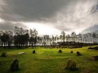
Stone cirles on Stanton Moor
Birchover and Stanton Moor: - This short walk 3 miles, taking around 2 hours takes in the major sights of Stanton Moor and Birchover, an area rich in historical associations and with superb views across the surrounding countryside. It gives an interesting outing for a winter's day, or one when covering a lot of distance doesn't seem important. On the way you can let your imagination wander as you consider the Bronze Age, druids and witches. Stanton Moor was a hive of activity in the Bronze Age as it is littered with over thirty-six cairns and recorder burial sites in addition to the Nine Ladies - a complex of prehistoric stone circles, traditionally believed to depict nine women who turned to stone as a penalty for dancing on Sunday!
The walk as described starts from a small lay-by on the B5056 opposite the track which leads up to Cratcliff Tor. This spot can be reached by car or by bus. Alternatively, you can save a bit of distance by starting from the bottom end of Birchover village, or you could extend the walk by starting from Elton and walking down Dudwood Lane, the line of the old Portway. Walk about 100 metres north along the B5056 to reach a stile on the right hand side. Cross it and head steeply off up the hillside. After about 100 metres you meet a track which contours around the hill. Turn left to follow it around to the other side of the hill but don't forget to look back at the fine view of Cratcliff Tor and Robin Hood's Stride across the valley. At the other side of the hill you meet the other branch coming around the hill - fork left and take the track which heads up towards Birchover.You soon arrive at the fantastic sight of Rowtor Rocks, an irregular jumble of gritstone blocks which have been embellished by the carving out of stone seats and steps. Most of this was done by the first incumbent of the Old Vicarage opposite, the Rev Thomas Eyre. The rocks make an excellent scramble and at the north end there is a rocking stone which can be moved with a firm push.Descend the north end of the rocks and you emerge almost in the Druid Inn, a distinctive hostelry and an alternative starting point for this walk. From the apex of the bend in the road, almost opposite the inn sign, a path leads up through the trees and takes a wooded ridge behind Birchover village. It's hard to make out whether it's a natural ridge or just quarry spoil - probably a mixture of both. This leads via a quarry car park onto the small road which links Birchover and Stanton. Turn left towards Stanton and follow it for about 200 metres. Then a cart track branches off to the right onto the moor, but don't take it immediately - continue along the road another 100 metres to admire the Andle or (Aigle) Stone which lies in a field below the road. There is a magnificent view of Youlgreave from here, and another up the valley towards Elton. Though there are druidic legends about these stones, this one is natural in origin and has metal rungs in it to aid ascent, plus an inscription commemorating the Duke of Wellington. It lies on private ground however. Return to the cart track and head up onto the moor. After 200 metres you arrive at the Cork Stone - another natural stone with rungs to aid ascent. Even so, you need to have long arms! Just past this stone the path branches - take the left fork and then fork left again to follow a track which passes about 100 metres west of the trig point.Follow this track for about 1 kilometre. It meanders around the tops of abandoned quarries with fine views of the Wye valley to Bakewell. Eventually it is forced eastwards by a fenced quarry and the track here is marked by gritstone markers in the ground. At the second fenced quarry a small path leads off right through the trees - this leads to the Nine Ladies stone circle. If you miss this path then don't worry - just continue along the track until it meets the main north-south track across the moor and turn right (south) and backtrack for a few hundred metres to the Nine Ladies.From the Nine Ladies take the main north-south track for a few metres and then branch left (south-east) along a track which leads across the moor to the tower at the eastern edge. This commemorates the Great Reform Act of 1832 but is now bricked up and in quite poor shape. At the tower turn right along a path which heads about south-south-west across the eastern edge of the moor - to the west of the fence which marks the boundary of the National Trust property. This path skirts the eastern edge, giving good views of the Derwent valley below until it arrives back at the boundary fence at a large natural stone - the Heart Stone. Continue in a south-westerly direction for another 200 metres and exit from the moor onto the minor road between Birchover and Stanton Lees.Turn right onto the road and after 50 metres cross a stile and follow a path which descends to Barn Farm below. This leads into the farmyard and you must go right around the farmbuildings in a clockwise direction to exit along the farm drive. You shortly arrive back in Birchover and can retrace your steps to the start.